Azores
Geography
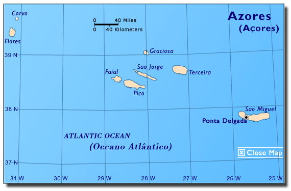
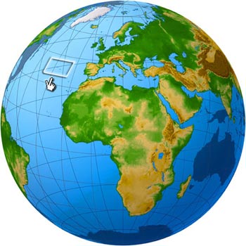 The Azores
archipelago is located about approximately 900 miles west
of mainland Portugal (1,500 kilometers west of Lisbon) and
2,423 miles from New York (3,900 kilometers from the east
coast of North America) (Azores, 2005). It is comprised of
nine islands: Corvo,
Faial, Flores, Graciosa, Pico, Santa Maria, São Miguel, São
Jorge and Terceira (UK Trade & Investment, 2005).
The total land area is 905 square miles (2,355 sq. kilometers)
(UK Trade & Investment, 2005). São Miguel, the largest
island, is home to Ponta Delgada, the largest city. Due to
its significant strategic location, in 1943 the United States
established the Lajes Air Base (Lajes Field,
2005) on Terceira Island (Vintras, 1974) . São Miguel Island
is home to Sete
Cidades the largest dormant volcanic crater in the world
(Mundt, n.d.).
The Azores
archipelago is located about approximately 900 miles west
of mainland Portugal (1,500 kilometers west of Lisbon) and
2,423 miles from New York (3,900 kilometers from the east
coast of North America) (Azores, 2005). It is comprised of
nine islands: Corvo,
Faial, Flores, Graciosa, Pico, Santa Maria, São Miguel, São
Jorge and Terceira (UK Trade & Investment, 2005).
The total land area is 905 square miles (2,355 sq. kilometers)
(UK Trade & Investment, 2005). São Miguel, the largest
island, is home to Ponta Delgada, the largest city. Due to
its significant strategic location, in 1943 the United States
established the Lajes Air Base (Lajes Field,
2005) on Terceira Island (Vintras, 1974) . São Miguel Island
is home to Sete
Cidades the largest dormant volcanic crater in the world
(Mundt, n.d.).
Climate
The Azores has a mild, temperate, humid,
maritime climate with a rainy season from November to March.
Temperatures range from 14-25° C (55-76° F) (Açores, 2003b).
History
The Portuguese discovered the nine islands of the Azores
archipelago in the fifteenth century. The exact date is unknown.
They were thought to be uninhabited
at the time (Azores.com, 2003). Santa Maria and São Miguel
were the first islands to be reached around 1497 by Diogo
de Silves. Others attribute their discovery to Gonçalo Velho
Cabral. Terceira was the third island to be discovered. The
islands of Graciosa,
S. Jorge, Faial, Pico, Flores and Corvo were discovered
later (Azores Tourist Guide, 2003). Settlement of the Azores
began in 1439 from the mainland of Portugal. The Azores became
an important source of grain and
cattle production for Portugal (Açores, 2005).
Because of their strategic location, the islands became a
stopping point between Europe, America, and Africa in the
16th and 17th century. As a result,
the Azores archipelago was the site of Naval battles when
it became a stopping point for pirates
around this time (Açores, 2005). Through time, Terceira
has played an important role in Portuguese history (Azores.com,
2003). For example, it was the last Portuguese territory to surrender
to Spanish sovereignty after
the succession of King Philip II of Spain to the Portuguese
throne in 1580, when Portugal lost its independence. In Terceira,
Angra Heroísmo
is the first city of the Azores and it holds a large and valuable
architectural heritage, which became part of UNESCO list of
World Patrimony in 1983 (Azores.com, 2003). In 1943, the United
States built the Lajes Air Base (Lajes Field,
2005) on Terceira Island because of its strategic location
(Vintras, 1974) .
Political Organization
 In
1976, the Azores became an
Autonomous Region of Portugal with a government led by an
elected President and a legislative branch known as a Regional
Assembly (Açores, 2003). The President and the members of
the Regional Assemblies are elected by popular vote. The President
appoints its cabinet and the Portuguese government appoints
the Minister of the Flag Republic to represent the central
government in the Autonomous Regions (Symington, 2000). In
1976, the Azores became an
Autonomous Region of Portugal with a government led by an
elected President and a legislative branch known as a Regional
Assembly (Açores, 2003). The President and the members of
the Regional Assemblies are elected by popular vote. The President
appoints its cabinet and the Portuguese government appoints
the Minister of the Flag Republic to represent the central
government in the Autonomous Regions (Symington, 2000).
Economy
The Azores is an important
tourism destination. The islands also produce dairy products
and beef for export (Açores, 2003).
|